In the Farmer Registry, your land is found through a chain of locations: state, district, sub-district (tehsil), village, and then the survey or khasra number of the plot. If any link in that chain is wrong, the portal cannot find your land. This page explains how that chain works, how to find the correct names and numbers, and what official district-level data exists.
Below the guide you will find a searchable table of Farmer IDs for all 75 districts of Uttar Pradesh, the only official district-wise table we have found so far, and links to every state portal.
How land is located in the Farmer Registry
Indian land records are kept village by village. The national AgriStack FAQ says that when your land is not shown automatically, you claim it by entering “the name of the district, subdistrict, and village where the land is located, along with the survey number and sub-survey number from their land records”.
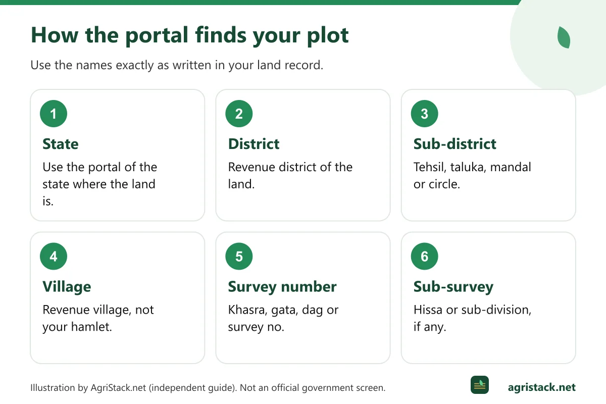
| Level | What it is | Examples of local names |
|---|---|---|
| State | Which state portal you use | Uttar Pradesh: upfr; Maharashtra: mhfr |
| District | Revenue district | Same as everyday district names, but check spellings |
| Sub-district | Revenue unit below the district | Tehsil, taluka, mandal, circle, block (varies by state) |
| Village | Revenue village where the land is recorded | May differ from the name of the hamlet you live in |
| Survey number | Number of the land parcel in the village record | Khasra, gata, survey, dag, plot number |
| Sub-survey number | Subdivision of a survey number | Hissa, sub-division, bata, or a suffix such as /1, /2 |
The revenue village may not be your hamlet
A common source of confusion: the village where your land is recorded is the revenue village, which can include several hamlets (majra, tola, wadi, pada). If you search for your hamlet name and do not find it, search for the revenue village it belongs to. Your land record (khatauni, 7/12, jamabandi, patta) shows the official village name.
Sub-district names vary by state
The level between district and village has different names: tehsil in Uttar Pradesh, Rajasthan, Madhya Pradesh and Haryana; taluka in Maharashtra, Gujarat and Karnataka; mandal in Andhra Pradesh and Telangana; circle in Bihar and Assam. Portals generally show it as “Sub-District”. Choose the unit named in your land record.
Step by step: finding your land details before registering
- Get a copy of your land record from your state's land record website or tehsil office. See official state land record portals.
- Note the district, sub-district and village exactly as written on the record.
- Note every survey or khasra number where you are an owner or co-owner, including sub-survey numbers.
- Check the owner name on each plot. Compare it with your Aadhaar name. Big differences will lower the name-match score.
- Check the area recorded against your name, especially for jointly held plots.
- Make a simple list with village and survey number for each plot. Take it with you if you register at a CSC or camp.
Finding your village on the portal
The Uttar Pradesh manual shows the typical flow: select the district, then the sub-district, then the village from dropdown lists, then type the survey number and press submit.
If your village does not appear:
- Check you chose the correct sub-district. Villages are listed only under their own tehsil.
- Try alternative spellings. Village names are often transliterated from the local language.
- Remember that recently created districts or tehsils may have moved your village.
- The village may not yet have been opened for registration in your state.
Our dedicated guide, Village not showing or wrong in Farmer Registry, goes through each of these.
Official village codes
Behind the scenes, government systems identify every village by an official code from the Local Government Directory (LGD), run by the Ministry of Panchayati Raj. The national AgriStack FAQ notes that states provide each farmer’s “village LGD code” when Farmer IDs are created. You do not normally need this code to register, but officials may use it to identify your village precisely, especially when names are spelt differently.
What district and village staff do in the registry
The Farmer Registry is run by State Governments, and much of the work happens locally:
- Village revenue officials (Lekhpal, Patwari, Talathi, VAO or Karamchari, depending on the state) verify land claims that are not approved automatically. In Uttar Pradesh, the official manual says claims with a name-match score between 16 and 79 go to the Lekhpal for approval.
- District administrations organise registration camps and help desks. The national FAQ says states may use “the administrative structure under the ‘Revenue’ and Agriculture department” for field verification.
- Agriculture department staff help farmers through the process and follow up pending cases.
If your claim is stuck, the people who can usually see why are at your tehsil and district agriculture office.
District-level Farmer ID data
Official district-wise data is limited. The Ministry of Agriculture published Farmer IDs for each district of Uttar Pradesh as on 30 July 2026 in a Lok Sabha reply dated 4 August 2026. The searchable table below reproduces it exactly as printed.
Some patterns in the Uttar Pradesh table:
- The districts with the most Farmer IDs were Azamgarh (7,58,877), Sitapur (7,26,097), Jaunpur (7,05,897), Hardoi (6,86,929) and Kheri (6,26,190). These are large rural districts with many small landholdings.
- The lowest counts were in largely urban districts near Delhi, such as Gautam Buddha Nagar (45,708) and Ghaziabad (62,853), where far fewer people farm.
- The district rows add up to 2,46,48,335, while the state figure in the same reply is 2,46,28,676. We show both and note the 19,659 difference.
A higher count in one district does not mean it is “ahead” of another. Districts have very different numbers of landholders. Our article on district-wise Farmer Registry coverage explains how to read such data and how to ask for figures for your own district.
Data for other states
We have not found official district-wise Farmer ID tables for other states. Some state portals display dashboards to logged-in officials, but we do not reproduce data we cannot verify publicly. For your district’s position, ask your district agriculture office or look for district-level press notes from your District Collector’s website.
Why we do not create a page for every district or village
Some websites publish thousands of near-identical pages such as “Farmer Registry [village name]” with no information specific to that village. Such pages do not help farmers, and search engines treat them as spam. We prefer one useful hub that explains how to find any village, plus genuine data where it exists. If official village-level data becomes public, we will consider adding it in a useful form.